


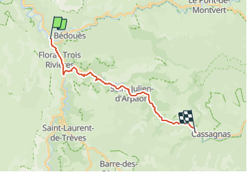
Etape 8 Florac/Cassagnas

Nathalie. Mercier
User


5h20
Difficulty : Medium

FREE GPS app for hiking
 SityTrail
IGN / Geographical institutes
SityTrail Plus
The world is yours!
About
Trail Walking of 20 km to be discovered at Occitania, Lozère, Florac Trois Rivières. This trail is proposed by Nathalie. Mercier.
Description
Départ tranquille en traversant Florac profitant de se ravitailler, il y en a pour tous les goûts , carrefour market , puis boulangerie suivie d une épicerie bio que je choisis , une belle tranche de pain avec 1 tranche de tomme ,2 abricots, qq fruits secs , très belle étape reposante par rapport à celle d hier à peine ressenti le dénivelé du départ, après St Julien, le sentier est sur l ancienne voie ferrée très beau parcours jusqu a l.ancienne gare
Photos


Positioning
Comments